The Tunnel of Love in Klevan, Ukraine
Klevan is a village about 25 km NW of the city of Rivne.
It was part of Poland between WWI and WWII.
This is an industrial track (apparently for a steel mill)
It was part of Poland between WWI and WWII.
This is an industrial track (apparently for a steel mill)
The Badlands Guardian. Coordinates: 50° 0’36.30″N, 110° 6’46.82″W.
The Badlands Guardian was one of those mysterious places
that was first discovered by Lynn Hickox utilizing the Google Earth program.
Even though this area is a natural formation, it is amazingly ironic
to see these arid badlands formations resemble the fully
detailed shape of the very same indigenous people that lived in these lands.
Machu Picchu. Coordinates: 13° 9’49.69″S, 72°32’42.65″W.
Located on a mountain ridge above the Urubamba Valley in Peru, Machu Picchu
is considered one of the most mystical sites on our planet.
Machu Picchu is a pre-Columbian Inca site built around 1400 AD.
Located on a mountain ridge above the Urubamba Valley in Peru, Machu Picchu
is considered one of the most mystical sites on our planet.
Machu Picchu is a pre-Columbian Inca site built around 1400 AD.
Cerne Abbas Giant. Coordinates: 50°48’49.00″N, 2°28’28.99″W.
The Cerne Abbas Giant, also known as the “Rude Man” or the “Rude Giant”
is a figure that stands 180 ft long and 167 ft wide.
It is carved in the hillside of Cerne Abbas, just north of Dorchester, England.
It’s origin and date is unknown...
The Cerne Abbas Giant, also known as the “Rude Man” or the “Rude Giant”
is a figure that stands 180 ft long and 167 ft wide.
It is carved in the hillside of Cerne Abbas, just north of Dorchester, England.
It’s origin and date is unknown...
Strange Carved Lines in China. Coordinates: 40°27’28.56″N, 93°23’34.42″E.
There isn’t much information available on these strange, yet beautiful mosaic
lines carved in the desert of the Gansu Sheng province in China.
Some records indicate they were created in 2004, but nothing that seems official.
There isn’t much information available on these strange, yet beautiful mosaic
lines carved in the desert of the Gansu Sheng province in China.
Some records indicate they were created in 2004, but nothing that seems official.
Atacama Giant. Coordinates: 19°56’56.88″S, 69°38’1.87″W.
Our last example of mysterious places found on Google Earth is also located
in the Atacama desert of Chile. The Atacama Giant is the
largest prehistoric anthropomorphic figure.
Our last example of mysterious places found on Google Earth is also located
in the Atacama desert of Chile. The Atacama Giant is the
largest prehistoric anthropomorphic figure.
Great Blue Hole in Belize -- Belize City (Source: Xinhuanet)
Salar de Uyuni is a magical place: When covered by water,
the world's largest salt flat becomes a mirror,
and anyone walking across it appears to be walking on clouds.
The salt crust, which covers 10 583 square kilometres
in southwestern Bolivia at 11,995 feet above sea level,
is nearly flat, which makes it ideal for
calibrating the altimeters of satellites.
Salar de Uyuni's origins lie in prehistoric lakes; it is a major
breeding ground for several species of flamingos.
Giants causeway in Ireland
Antelope Canyon in U.S.

The Nazca Lines are a series of geoglyphs located in the Nazca Desert,
a high arid plateau that stretches 53 miles or more than 80 kilometers
between the towns of Nazca and Palpa on the Pampas de Jumana in Peru.
a high arid plateau that stretches 53 miles or more than 80 kilometers
between the towns of Nazca and Palpa on the Pampas de Jumana in Peru.

The Easter Island is one of the most isolated pieces of land in the world.
This volcanic island in the South Pacific has its nearest neighbors, Chile and Tahiti,
2000 miles away. If you are from North America, you have to take an airplane,
another aircraft, and a boat to see the famous Easter Island statues.
This volcanic island in the South Pacific has its nearest neighbors, Chile and Tahiti,
2000 miles away. If you are from North America, you have to take an airplane,
another aircraft, and a boat to see the famous Easter Island statues.
This is one of the most mysterious places of Russian North.
Those stone idols attract tourists from all the Russia.
They stand alone on the wide plateau with no any stones or mountains around.
Those stone idols attract tourists from all the Russia.
They stand alone on the wide plateau with no any stones or mountains around.
One of the most famous and most mysterious places on our planet who adore travelers
- a rock Devils Tower, located in the reserve in northeast Wyoming in the U.S.
- a rock Devils Tower, located in the reserve in northeast Wyoming in the U.S.
Karakum Desert inTurkmenistan
Abandoned mill from 1866 in Sorrento, Italy
Czestochowa, Poland’s abandoned train depot
Abandoned city of Keelung, Taiwan
Lawndale Theater in Chicago
Nara Dreamland in Japan
Kalavantin Durg near Panvel, India
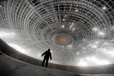
House of the Bulgarian Communist Party
El Hotel del Salto in Colombia
Angkor Wat in Cambodia


